
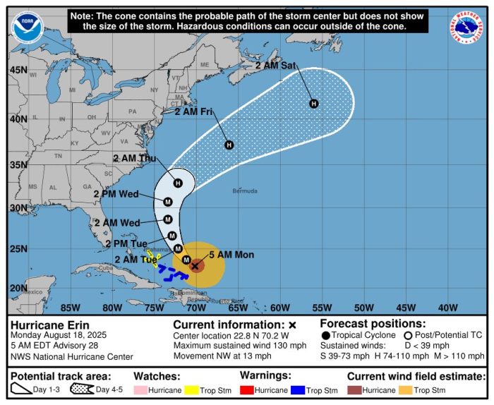
Officials in Dare and Hyde counties have issued mandatory evacuation orders for Hatteras and Ocracoke Islands ahead of Hurricane Erin, which strengthened overnight into a Category 4 storm. While Erin is forecast to remain offshore, the storm is expected to drive life-threatening surf, flooding, and winds across the Outer Banks beginning Tuesday.
The National Weather Service in Newport/Morehead City warned Monday morning that “impacts will be extremely dangerous for parts of Coastal Eastern North Carolina as Erin will be very large in nature, and significant impacts will occur well away from the cone of uncertainty.”
Timing and Conditions
Impacts are expected to begin on Tuesday, with the most dangerous conditions peaking Wednesday into Thursday as Erin makes its closest approach to the region.
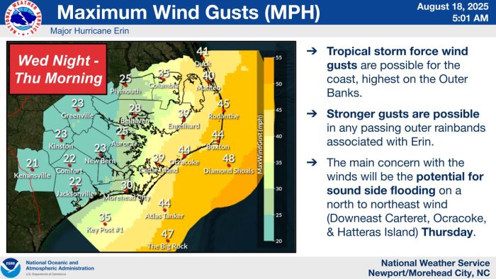
- Winds: Tropical-storm-force winds of 35–50 mph are likely along the coast, with stronger gusts possible on exposed stretches of Hatteras and Ocracoke.
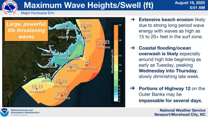
- Waves: Seas are forecast to build to 15–20 feet offshore of Hatteras and Ocracoke, with some areas near Diamond Shoals and The Point seeing waves as high as 20–25 feet.
- Flooding/Overwash: Oceanside flooding and overwash are expected at high tide cycles beginning as early as Tuesday. The flooding threat will peak Wednesday into Thursday, with significant beach erosion also likely.
- Travel Impacts: Portions of N.C. Highway 12 on Hatteras and Ocracoke are likely to become impassable for several days, cutting off access to villages and critical routes.
- Rip Currents: All beaches along the Outer Banks will face strong and life-threatening rip currents starting Tuesday.
Evacuations Ordered
Local officials stressed that preparations should not be delayed.
- Hatteras Island (Dare County): A mandatory evacuation order for visitors went into effect at 6 a.m. Monday, August 18, with a mandatory evacuation for residents beginning at 8 a.m. Tuesday, August 19. The order applies to all of Hatteras Island, including the villages of Rodanthe, Waves, Salvo, Avon, Buxton, Frisco, and Hatteras.
- Ocracoke Island (Hyde County): A mandatory evacuation for both residents and visitors took effect at 6 a.m. Monday, August 18. Hyde County officials also noted that a Flood Watch is in effect, warning of possible flash flooding due to storm surge and heavy rains.
Ferry service to Ocracoke will be running on limited schedules until conditions deteriorate, and travelers are urged to leave as early as possible before service is suspended.
Emergency management officials urge those under evacuation orders to leave immediately and not attempt to ride out the storm on the islands. Visitors should check with accommodations and rental agencies for re-entry information once conditions improve.
A list of local Outer Banks resources for information is below.
- For alerts and notifications from Dare County on a customizable list of events or emergencies, (including hurricane evacuations and updates), visit https://www.darenc.gov/departments/emergency-management/emergency-alerts.
- For rip current information and other beach hazards, sign up for text alerts from Dare County, ocean rescue agencies, and the National Weather Service by texting “OBXBeachConditions” to 77295.
- For real-time flood maps that show water level rises throughout Hatteras and Ocracoke Islands, (as well as optional alerts), visit the NC Flood Inundation Mapping and Alert Network.
- For information on the local forecast, visit weather.gov/mhx for general weather information, or the National Weather Service office in Newport/Morehead City’s Facebook page at https://www.facebook.com/NWSMoreheadCity/.
- For up-to-date information on tropical conditions, follow the NWS at gov/mhx/tropical or visit the National Hurricane Center’s website. Just pay attention to all info, and not just the cone graphics.
- To sign up for the Special Needs Registry for hurricane assistance through Dare County, visit https://www.darenc.gov/departments/health-human-services/special-medical-needs-registry or call 252-475-5599.
- For Dare County hurricane information, including reentry procedures, visit https://www.darenc.gov/departments/emergency-management/hurricanes.
- For updates regarding road conditions, visit DriveNC.gov and follow the North Carolina Department of Transportation and NCDOT NC 12 on Facebook. The Dare County Sheriff’s Office also shares local road condition updates on its Facebook page.
- To get notified of ferry delays or cancellations, sign up for text and/or email alerts via the N.C. Ferry System’s FINS system: www.ncdot.gov/fins.
- For up-to-the-minute local information on hurricanes, as they happen, listen to Radio Hatteras at 101.5 (Avon through Hatteras) and 99.9 (Tri-villages), or visit them online at https://www.radiohatteras.org/.
- For online news coverage on active storms, continue to check the Island Free Press.
The post Mandatory evacuations in effect for Hatteras and Ocracoke Islands as Hurricane Erin strengthens overnight to a Category 4 storm appeared first on Island Free Press.

 Add to favorites
Credit: Original content published here.


