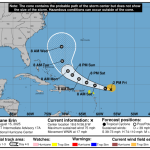
The center of Hurricane Erin churned more than 200 miles offshore, but its massive size still brought damaging storm surge, severe ocean overwash, and evacuations along parts of the Outer Banks, according to post-storm reports from the National Weather Service and county emergency managers.
Officials stressed that Erin’s impacts were largely confined to surf, surge, and travel disruptions, and no injuries or fatalities were reported.
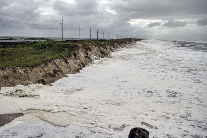
The first hurricane of the 2025 season in the Atlantic basin made its closest approach to North Carolina during the morning of August 21, driving seas onto N.C. Highway 12 in multiple spots on Hatteras and Ocracoke islands.
Large portions of the highway, including stretches on Ocracoke between the Pony Pens and Hatteras Inlet, outside Hatteras village, in north Buxton, near the Pea Island Visitor Center, and the Canal Zone south of Oregon Inlet were impassable for days due to sand and ocean water.
Dare County Emergency Management Director Drew Pearson estimated about 80,000 visitors and residents evacuated from Hatteras Island, while another 1,200 people were ferried off Ocracoke Island before conditions worsened according to Hyde County spokesperson Donnie Shumate.
Highway 12 on Hatteras Island reopened August 23, and on Ocracoke on August 25.
In the four-wheel drive area north of Corolla, an estimated 4,000 visitors were asked to evacuate as a precautionary response to the heightened coastal threat, and a large majority of visitors complied, according to Currituck County Deputy Emergency Management Coordinator Olivia Doherty.
Currituck lifted its evacuation order on August 22.
Preliminary damage assessments in Buxton showed damage to 56 homes and four businesses, including driveways, parking lots, as well as septic systems and pipes, while a Rodanthe campground reported damage to travel trailers.
Debris removal in oceanfront neighborhoods, mainly along Old Lighthouse Road in Buxton, is expected to be extensive due to sand, vegetative and flood-related waste.
No structural damage was reported in Dare’s six incorporated towns on the north beach, on Roanoke Island, nor along the Currituck Outer Banks and mainland.
Wind gusts reached 45 knots, about 52 mph, along the Outer Banks, while storm surge pushed water levels to 3.36 feet above mean higher high water at the Army Corps of Engineers Research Pier in Duck, and 2.39 feet at the Coast Guard station in Hatteras, the weather service said.
At Duck, the peak high tide on Thursday evening reached major flood stage at 7.04 feet, the fifth-highest tide height ever recorded at the site.

According to the Coastal Studies Institute, the largest individual waves recorded during Hurricane Erin in the waters off the Outer Banks was approximately 30.5 feet at a buoy ten miles east of Buxton, just over 29 feet at a buoy eight miles south of Oregon Inlet, and about 29.5 ft by a buoy ten miles off Nags Head.
A buoy east of Virginia Beach recorded its third-largest significant wave height in station history with nearly 25-foot seas. There, the highest individual wave measured during Hurricane Erin reached just over 40 feet tall.
Minor soundside flooding with no damage occurred in Hatteras and Ocracoke villages.
Tyrrell County reported minor flooding along Highway 94 near the Alligator River. Other inland counties recorded little to no effect from the storm.
No rainfall above 3 inches was observed, and the storm produced no tornadoes across eastern North Carolina.
The post By the numbers: Hurricane Erin’s impacts along the Outer Banks appeared first on Island Free Press.

 Add to favorites
Credit: Original content published here.