A coastal low pressure system is expected to produce strong northeast winds, large surf, and periods of coastal flooding and ocean overwash along the Outer Banks, according to the latest update from the National Weather Service (NWS) office in Newport/Morehead City.
Forecasters warn that significant ocean overwash will likely impact vulnerable stretches of N.C. Highway 12 on Hatteras and Ocracoke Islands, making the highway inaccessible at times.
Coastal flooding is forecast along the oceanfront up to three hours before and after high tide, which is around midnight and noon on Tuesday, 1 a.m. and 1:30 p.m. on Wednesday, 2 a.m. and 2:30 p.m. on Thursday, and 3:30 a.m. and 3:30 p.m. on Friday.
Oceanside inundation of 2 to 3 feet above ground level is expected, along with 1 to 2 feet of flooding in low-lying areas adjacent to the southern Pamlico Sound and nearby rivers, including the Neuse, Bay, Pamlico, and Pungo Rivers.
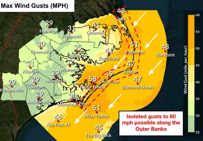
Wind gusts of 45 to 50 mph are likely, with isolated gusts reaching up to 60 mph along the Outer Banks. Persistent northeast winds will drive elevated water levels and rough surf from Cape Lookout northward to Duck.
The NWS notes a low-end chance for higher water rises—up to 3 feet above ground level—along the southern Pamlico Sound and Neuse River. Rough surf and localized beach erosion are also expected throughout the Outer Banks.
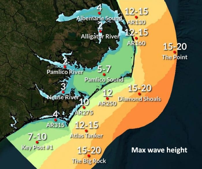
A Coastal Flood Warning and Gale Warning remain in effect for all coastal waters, sounds, and rivers, with winds of 35 to 45 knots continuing through Wednesday morning. Seas are forecast to peak Tuesday evening at 15 to 20 feet offshore and remain elevated for much of the week.
While periods of heavy rain are possible through midweek, rainfall impacts are expected to remain low.
N.C. Highway 12 is open and passable as of 7:00 a.m. Tuesday, with blowing sand and standing rainwater in some stretches. Hatteras-Ocracoke ferry service was suspended Monday evening due to deteriorating weather conditions.
Forecasters are also monitoring a separate low-pressure system that could bring additional impacts to eastern North Carolina later this week.
The next full weather briefing from the NWS Newport/Morehead City office is expected by 6 p.m. Tuesday unless forecast changes warrant an earlier update. For local conditions and updated advisories, visit weather.gov/mhx.
The post Coastal flood warning in effect as ocean overwash expected along Outer Banks appeared first on Island Free Press.

 Add to favorites
Credit: Original content published here.