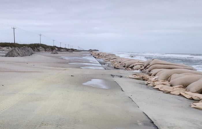
Ocean overwash was reported in Buxton on Wednesday morning, roughly three hours before high tide, as a low pressure system continues to impact the Outer Banks.
N.C. Highway 12 remains closed on Hatteras Island between Rodanthe and the Marc Basnight Bridge, and on northern Ocracoke Island as of 10 a.m., according to the North Carolina Department of Transportation (NCDOT).
“Our crews will be out working to clear the road in advance of the 1:40 p.m. afternoon high tide,” stated the NCDOT. “Please give them room to work.”
Minor to moderate coastal flooding and ocean overwash will persist along portions of Hatteras and Ocracoke Islands on Wednesday as large waves and elevated water levels continue, according to the National Weather Service (NWS) Newport/Morehead City office. While northeast winds are slowly diminishing, surf conditions remain rough, and vulnerable areas will continue to experience flooding through multiple upcoming high-tide cycles..
Ferry operations resumed Wednesday morning on both the Ocracoke–Cedar Island and Ocracoke–Swan Quarter routes after being suspended Tuesday because of hazardous marine conditions. Hatteras–Ocracoke ferry operations continue to be suspended due to overwash and debris on N.C. Highway 12.
Coastal flooding remains likely up to three hours before and after each high tide, with the next high tide expected around 1:40 p.m. Wednesday, followed by 2 a.m. and 2:30 p.m. Thursday, and 3:30 a.m. and 3:30 p.m. Friday. Oceanside inundation of 2 to 3 feet above ground level is possible in low-lying oceanfront areas, while 1 to 2 feet of flooding may occur along the southern Pamlico Sound and adjacent rivers, including the Neuse, Bay, Pamlico, and Pungo Rivers.
Five homes collapsed in Buxton on Tuesday amid the strong northeast winds and high surf, but no additional collapses were reported overnight. Dangerous debris and unstable structural materials remain scattered along the shoreline, and the public is urged to avoid the area.
The NWS is also monitoring a separate low-pressure system expected to move across eastern North Carolina late Wednesday night into Thursday, which could bring a low-end severe weather threat and minor additional coastal impacts later in the week.
For local weather advisories and updates, visit weather.gov/mhx.

The post Ocean overwash reported ahead of Wednesday afternoon’s high tide appeared first on Island Free Press.

 Add to favorites
Credit: Original content published here.