Coastal flooding and ocean overwash are already underway on the Outer Banks as Hurricane Erin churns offshore, and conditions are expected to worsen through Wednesday and Thursday, according to the National Weather Service (NWS) Newport/Morehead City office.
Ocean overwash was reported on Tuesday afternoon, and occurred again on Wednesday morning ahead of the 5:45 a.m. high tide, at multiple locations along N.C. Highway 12, including Pea Island, northern Buxton, northern Hatteras Village, and northern Ocracoke Island. Travel is not recommended, especially in the hours before and after high tide. The next high tide is approximately 6:15 p.m. Wednesday.
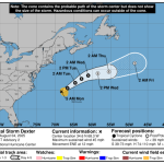
As of Wednesday morning, a Storm Surge Warning and a Tropical Storm Warning remain in effect for the Outer Banks, with mainland Dare County and the Albemarle Sound/Alligator River newly added to the tropical storm alerts.
Forecasters warn that the impacts will be prolonged and severe. Oceanside inundation of 2 to 4 feet above normally dry ground is expected, with the highest water levels lingering through Friday. N.C. Highway 12 on Hatteras and Ocracoke Islands is at risk of being impassable for several days due to significant wave run-up and flooding. Vehicles left along low-lying roads may be submerged.
Large, dangerous surf is one of the storm’s most pressing threats. Waves of 15 to 20 feet or higher are forecast in the surf zone, leading to widespread beach erosion, dune loss, and structural damage near the coastline. The most severe oceanside flooding and overwash are anticipated late Wednesday into Thursday, coinciding with high tides.
Tropical-storm-force winds are expected to arrive as early as Wednesday morning, with the strongest gusts Wednesday night through Thursday afternoon. The NWS notes that the most powerful winds will impact the Outer Banks and adjacent sounds, with soundside flooding possible Thursday into Friday, especially in areas exposed to north and northeast winds such as Ocracoke, Hatteras, and Downeast Carteret County.
Rip currents remain life-threatening across all area beaches this week, with extremely dangerous surf peaking midweek and continuing into Friday.
Officials urge residents and visitors to move vehicles to higher ground and prepare for extended road closures, particularly on NC-12. “Do not focus on the exact track of Erin,” the NWS cautioned. “Impacts can occur well outside the cone.”


A list of local Outer Banks resources for information is below.
- For alerts and notifications from Dare County on a customizable list of events or emergencies, (including hurricane evacuations and updates), visit https://www.darenc.gov/departments/emergency-management/emergency-alerts.
- For rip current information and other beach hazards, sign up for text alerts from Dare County, ocean rescue agencies, and the National Weather Service by texting “OBXBeachConditions” to 77295.
- For real-time flood maps that show water level rises throughout Hatteras and Ocracoke Islands, (as well as optional alerts), visit the NC Flood Inundation Mapping and Alert Network.
- For information on the local forecast, visit weather.gov/mhx for general weather information, or the National Weather Service office in Newport/Morehead City’s Facebook page at https://www.facebook.com/NWSMoreheadCity/.
- For up-to-date information on tropical conditions, follow the NWS at gov/mhx/tropical or visit the National Hurricane Center’s website. Just pay attention to all info, and not just the cone graphics.
- To sign up for the Special Needs Registry for hurricane assistance through Dare County, visit https://www.darenc.gov/departments/health-human-services/special-medical-needs-registry or call 252-475-5599.
- For Dare County hurricane information, including reentry procedures, visit https://www.darenc.gov/departments/emergency-management/hurricanes.
- For updates regarding road conditions, visit DriveNC.gov and follow the North Carolina Department of Transportation and NCDOT NC 12 on Facebook. The Dare County Sheriff’s Office also shares local road condition updates on its Facebook page.
- To get notified of ferry delays or cancellations, sign up for text and/or email alerts via the N.C. Ferry System’s FINS system: www.ncdot.gov/fins.
- For up-to-the-minute local information on hurricanes, as they happen, listen to Radio Hatteras at 101.5 (Avon through Hatteras) and 99.9 (Tri-villages), or visit them online at https://www.radiohatteras.org/.
- For online news coverage on active storms, continue to check the Island Free Press.


The post Ocean overwash threat continues on Wednesday, Storm Surge Warning and Tropical Storm Warning remain in effect appeared first on Island Free Press.

 Add to favorites
Credit: Original content published here.