Hazardous ocean conditions are expected to develop along the Outer Banks starting Sunday and continuing through much of the upcoming week as Hurricane Humberto and Tropical Depression 9 (TD 9) generate large, long-period swells along the East Coast.
The latest update from the National Weather Service (NWS) Newport/Morehead City office warns that surf and rip current risks will increase significantly beginning Sunday afternoon, with dangerous conditions likely to persist for multiple days as both systems influence the region.
According to the National Weather Service, confidence continues to increase regarding impacts from long-period swell from both TD 9 and Hurricane Humberto, which is now a major Category 5 hurricane. Forecasters stress that this has the potential to be a longer-duration swell event for the eastern North Carolina coastline, with the peak impacts expected Tuesday through Thursday. Additional coastal and inland impacts are possible depending on the track of TD 9, which remains uncertain.
Peak offshore wave heights are expected to reach 15-20 feet by Thursday, creating powerful shore break and strong rip currents that will affect all beaches, especially those with existing dune vulnerabilities
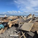
“Ocean conditions will become life-threatening and the potential for impacts from the long-period swell and large surf are growing. Those along the oceanfront, especially in areas with compromised dune structures, will see the greatest potential for impacts,” said Drew Pearson, Dare County Emergency Management Director. “We could also see soundside flooding impacts as a strong northeasterly flow develops as the storms move to the east. Continue to keep an eye on the forecast and be ready to take actions to protect property as we move into next week.”
Heavy rainfall and flooding risks may linger into early next week, especially for the southern regions, where higher rainfall amounts are expected compared to northern Outer Banks areas. The rainfall forecast remains highly dependent on the track of TD 9
While Humberto’s track remains well offshore, confidence is low regarding the exact path and potential inland impacts of TD 9. The interaction between the two systems will be complex, and small changes in TD 9’s movement could shift local impacts.
Residents, visitors, and oceanfront property owners are urged to monitor official forecasts from the National Weather Service and local emergency management agencies.
For information on the local forecast, visit weather.gov/mhx for general weather information, or the National Weather Service office in Newport/Morehead City’s Facebook page at https://www.facebook.com/NWSMoreheadCity/.


The post Outer Banks faces long-duration swell event this week from Humberto and TD 9 appeared first on Island Free Press.

 Add to favorites
Credit: Original content published here.