
A stalled frontal boundary to the south, coupled with high pressure to the north, has combined to create strong onshore winds and stir up the ocean along the Outer Banks.
And a low pressure system has formed offshore of North Carolina that is being monitored for possible tropical development.
Northeast winds of 25 to 30 mph and occasional higher gusts are forecast to continue into Sunday evening, and is creating breaking waves of 5 to 8 feet in the surf zone along the east-facing beaches from the state line to Cape Hatteras.
That has led the National Weather Service to issue a High Surf Advisory through Sunday night from Carova to Buxton.
There was some minor overwash reported in northern Buxton with Saturday afternoon’s high tide, the area from the motels to Old Lighthouse Beach that has no front dune.
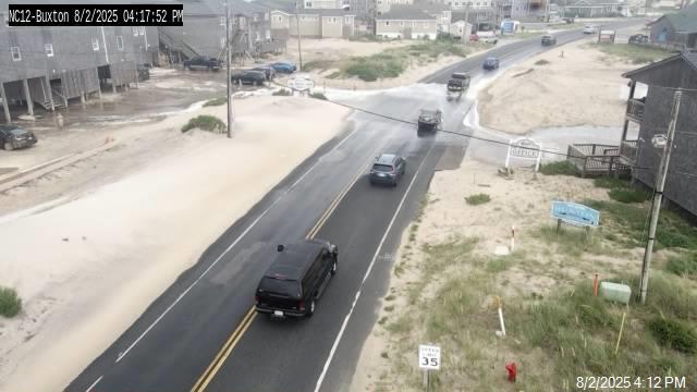
That stretch of beach is prone to overwash anytime there is steady north or northeasterly winds.
There has also been erosion of the beach south of Buxton village along the former Navy and Coast Guard base site that has led the National Park Service to close 3/10ths of a mile of beach between the end of Old Lighthouse Road and the jetty near the former location of the Cape Hatteras Lighthouse.
That’s after more remaining infrastructure abandoned by the military was exposed, and a light sheen and smell of petroleum, was reported today.

It is the same area that had been closed between September 2023 and this past June.
The Army Corps of Engineers had led a clean-up of what is know as the Buxton Formerly Used Defense Site, and was to begin further monitoring for more potential pollution sources.
- Read more: Cape Hatteras National Seashore temporarily closes shoreline at Buxton Formerly Used Defense Site
There were no other reports of overwash elsewhere on the Outer Banks, but some stretches of beach along the Currituck four-wheel drive area, Corolla, Duck, Southern Shores, Kitty Hawk, Kill Devil Hills, Nags Head, South Nags Head, Bodie Island, Pea Island, Rodanthe, Waves, Salvo, Avon, and northern Ocracoke saw waves running up to the toe of the dunes.
The next high tides are around 3:30 a.m. and 4 p.m. on Sunday, when there could be additional overwash.
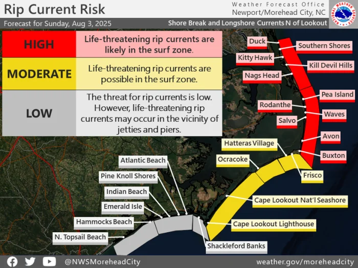
A high risk of rip currents has also been forecast to continue for all of the beaches from Carova to Buxton, and double red flags which means ocean swimming is banned, are expected to fly again on Sunday.
Along the southern Hatteras Island and Ocracoke beaches, a moderate risk is expected through Sunday. Only experienced surf swimmers who know how to escape a rip current should be in the ocean off Frisco, Hatteras village and Ocracoke Island.
Beachgoers should also be aware of powerful shorebreak that can easily knockdown and injure anyone standing or walking along the water.
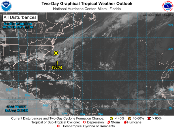
Meanwhile, the National Hurricane Center is now monitoring for possible tropical development in the next couple of days a low pressure system that developed along the stalled frontal boundary to our south.
NHC forecasters are giving the low that is about 150 miles off the North Carolina coast a 30% chance of becoming a tropical cyclone over the next 48 hours.
“This system could acquire some tropical or subtropical characteristics through Monday while it moves east-northeastward at about 10 mph away from the coast of North Carolina,” NHC said Saturday night. “Environmental conditions become less conducive for development after Monday.”
While that system moves away, weaker lows will continue to ride the stalled frontal boundary, keeping our weather unsettled through late next week.
While it won’t be a total washout, we will have a chance of scattered showers and thunderstorms at times.
After a brief respite from the recent heat wave on Saturday, as temperatures have stayed in the upper 70s, we’re in the low 80s on Sunday and then more seasonal temps next week.
The onshore flow will also continue next week, with northeasterly winds easing down to around 10 to 15 mph, with an occasional gust around 20.
Seas of 4 to 7 feet are forecast for the coastal waters, which will likely keep the surf rough along the beaches and Small Craft Advisory pennants flying this coming week.

The post Strong onshore winds producing rough surf, high risk of rip currents along the Outer Banks appeared first on Island Free Press.

 Add to favorites
Credit: Original content published here.
