Storm-driven damage on the Outer Banks—or any coastal town in North Carolina—is nothing new. Hurricanes like 1991’s Emily and 2003’s Isabel wiped out swaths of homes, while 2011’s Hurricane Irene closed N.C. Highway 12 for weeks after cutting three new inlets through Pea Island, and ripping apart sections of the roadway.
But the Buxton situation—and, more accurately, the Hatteras and Ocracoke Islands situation—is different.
That’s why it has drawn so much intense, sustained attention from local residents, far beyond the fleeting headlines and viral videos of houses falling into the ocean. What’s happening on Hatteras Island goes far deeper than the shocking images—it’s a cascading crisis that touches nearly every part of daily life, from infrastructure and education, to safety and community resilience that’s increasingly difficult to maintain.
And it’s why residents are building a local, statewide, and even nationwide call for help. Because the problem isn’t confined to one neighborhood or even one village—it’s island-wide, and it’s growing.

It’s not just about Buxton – it’s about the Outer Banks
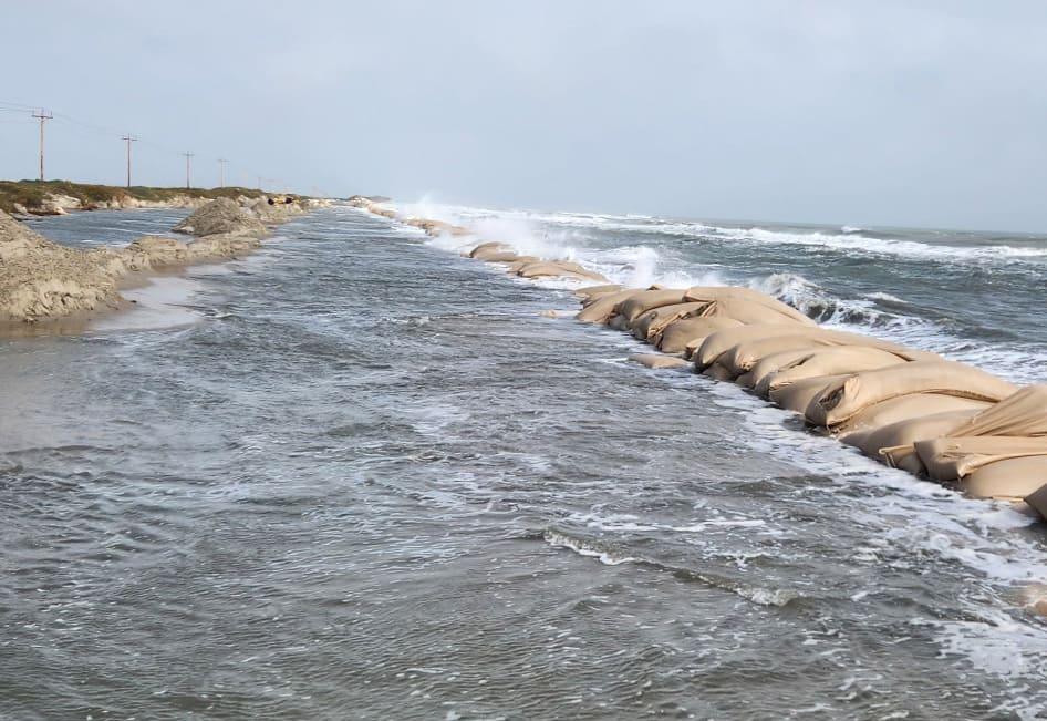
N.C. Highway 12—the lifeline that connects Hatteras Island’s villages to the mainland—has been repeatedly compromised by flooding and overwash, not only in Buxton but more frequently on Pea Island and northern Ocracoke.
On Pea Island, erosion continues to chew at the shoulders of the highway near the northern ‘Canal Zone’ and the Pea Island Visitor Center, while the north end of Ocracoke remains particularly fragile, often closing for days at a time due to ocean overwash.
The impact on education has been stark. In the first 48 school days of the year, Cape Hatteras Elementary and Secondary Schools have canceled, delayed, or converted to remote learning more than a dozen times. In comparison, schools north of Oregon Inlet—on the same county calendar—have missed only two days.
Local officials, including the N.C. 12 Task Force, have long warned that maintaining access along the island’s only highway is one of the region’s most urgent challenges. The Task Force’s final 2023 report outlined “seven vulnerable hotspots” on Hatteras and Ocracoke Islands and recommended detailed long-term solutions, ranging from road relocations and bridges to engineered protections. Yet, as this fall’s series of collapses and closures make clear, those recommendations are still waiting to be implemented.
“It’s not a new problem,” said one longtime Buxton resident at the Buxton Civic Association’s monthly meeting on Nov. 5. “But it’s reaching a new level of urgency.”
It’s not just about fallen homes — it’s about the fallout
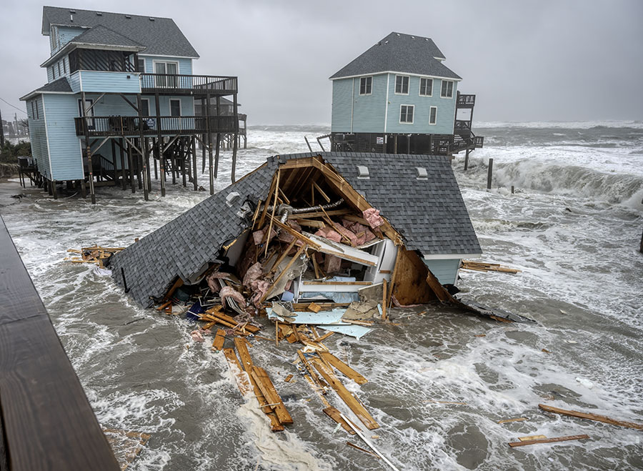
Since September 16, fifteen houses in Buxton have fallen into the Atlantic Ocean—along with one in Rodanthe—marking a first-of-its-kind string of structural failures. Five homes collapsed in a single day twice within one month, on September 30 and again on October 28—a scenario not seen in recent history along the Outer Banks, and never without the trigger of a stand-alone major storm.
27 oceanfront homes have fallen since 2020, which means that roughly 60% of home collapses over the past five years have occurred within the past two months.
“This isn’t like any storm we’ve ever dealt with,” said BCA board member Brett Barley. “It’s not one hurricane and then recovery—it’s ongoing. We need some kind of organization, some sort of ringleader, to help coordinate what’s going on out there.”
That ongoing nature is precisely what makes the home collapse predicament so complex. After a hurricane, cleanup usually begins when the skies clear—homeowners assess damage on their own property, contractors start rebuilding or removing debris, and volunteers help collect patches of excess debris when needed. But in Buxton, the impacts keep coming. Each new cycle of high surf or a distant nor’easter brings more damage, more debris, and more confusion over who is responsible.
The mess doesn’t stop at the waterline. Debris from the fallen homes—everything from lumber and shingles to furniture, septic tanks, and household waste—has spread for miles. It has inundated side streets, private yards, and the Cape Hatteras National Seashore, creating a dangerous and ongoing environmental hazard.
According to the National Park Service, very few owners of collapsed homes have requested Special Use Permits required for debris removal along Seashore property. As a result, much of the cleanup has fallen to Seashore staff, county debris collections, community groups, and volunteers.
“It’s like a square mile debris field,” said Barley. “How do we go about tackling this? How do we help hold homeowners accountable? Some are waiting to see what the [Buxton] Civic Association organizes before they hire anyone to clean up.”
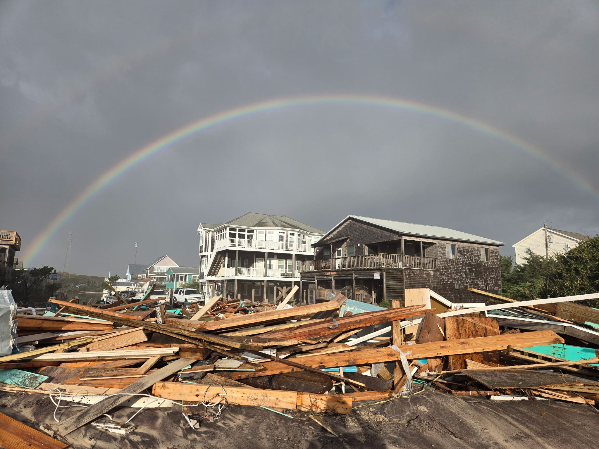
Lat Williams, who has a background in insurance and attended the Nov. 5 meeting, added that the problem isn’t just the size—it’s the overlap. “When you have five houses fall on the same day, it’s all mixed up,” he said. “You can’t tell where one property ends and another begins.”
That confusion has spurred the BCA to take a leadership role, even as members stress they are a volunteer organization with limited capacity.
“People reach out after every event now asking, ‘When’s the cleanup? What can I do?’” said Heather Jennette, BCA president. “We want to harness that energy but make sure it’s coordinated and safe. Some sites need strong volunteers with chainsaws, not just people with grabbers and trash bags.”
To streamline efforts, the association has launched an email list to notify volunteers about upcoming cleanups once heavy debris removal is complete.
The goal, Jennette said, is to “fill in the gaps” between what private contractors and county crews can do—and what the community still needs.
It’s a similar response to past storms, like 2019’s Hurricane Dorian, where a “home base” was set up at the Frisco Volunteer Fire Station so visitors and residents could offer help or ask for it.
But unlike past storms, the recovery isn’t just for a single storm – it’s ongoing, without an immediate end in sight.

It’s not just about today’s shoreline — it’s about decades of shaping it
Few outside Buxton realize that the area now facing accelerated erosion once housed a U.S. Navy facility—the Buxton Naval Facility, part of a Cold War–era network of underwater listening stations known as the Sound Surveillance System (SOSUS).
The site was decommissioned in the 2010s after being subsequently used by the U.S. Coast Guard, and is now designated a Formerly Used Defense Site (FUDS), managed by the U.S. Army Corps of Engineers.
But its presence still shapes the shoreline today. Three rock and metal groins (or jetties as they are commonly called in local circles) built between 1969 and 1970 were intended to protect the Navy’s infrastructure and stabilize the beach.
While natural erosion and shifting ocean currents have always influenced the Outer Banks, many locals believe that these hardened structures—and their gradual deterioration after being left unmaintained—have fundamentally changed how the shoreline behaves. They say the jetties have altered the way sand moves along the coast, creating pockets of accelerated loss in some areas and unnatural buildup in others, compounding the effects of storms and sea level rise over time.
At the BCA meeting, Barley noted that “as the oceanfront is changing, the debris spreads differently each time. What used to stay along the shoreline now moves inland, because everything is flat.”
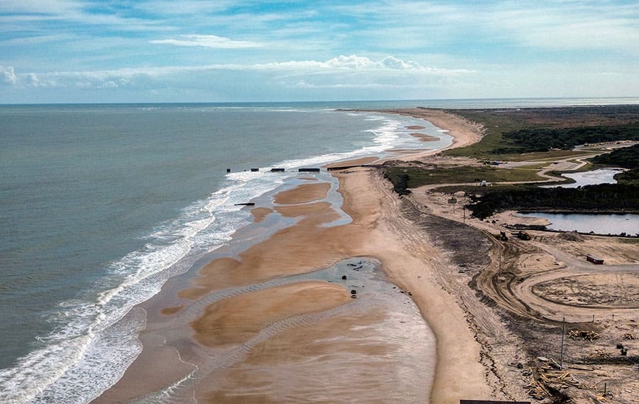
The Corps is currently overseeing a multi-phase remediation project at the FUDS site to remove contaminated soil and reinforce the area. A potential long-term solution is also in motion: the southernmost jetty is slated for repair in the summer of 2026, to coincide with a planned Buxton beach nourishment project.
But until then, residents face another winter of nor’easters and oceanfront losses. And a state law against hardened structures – like groins or jetties – currently make additional repairs to the other two severely deteriorated jetties an impossibility.

It’s not just about what’s happened — it’s about what’s coming next
Nearly everyone involved—residents, officials, contractors, and environmental groups—agrees on one grim certainty: more homes are on the brink of collapse, and the highway will flood again.
“This isn’t going to just get cleaned up in a week,” Barley said. “It’s going to happen again. We need to think about how we’re going to survive the next six months.”
That means more debris, more cleanup efforts, and more strain on local infrastructure. With a beach nourishment and jetty repair project still months away (and unable to be pushed forward due to the constraints of winter weather conditions), the BCA and other community leaders say it’s crucial to stay organized, prepared, and vocal.
As BCA co-vice president Brian Harris put it, “Right now, it’s pieced together. We have people covering certain streets and doing their best, but this situation is far bigger than any one group.”
Local residents and stakeholders plan to continue organizing cleanups and maintaining communication with state and federal officials. The goal is not just to pick up debris, but to keep attention on the long-term, systemic issues—erosion, infrastructure, and maintaining N.C. Highway 12, and the need for consistent, proactive management.
“This isn’t about pointing fingers,” Jennette said. “It’s about figuring out how we move forward as a community, because this is going to keep happening—and we have to be ready.”
“If this were a single hurricane, everyone would know what to do,” said Barley. “But this is different. It’s not over—it’s ongoing.”
It’s not just about short-term fixes — it’s about long-term solutions
There is no easy solution to the challenges Buxton and Hatteras and Ocracoke Islands now face. The upcoming jetty repair and 2026 beach nourishment will help buy time for Buxton and may slow the rate of erosion, but they will not stop it.
The construction of N.C. Highway 12 decades ago created a fixed line of infrastructure that must now be defended. Roads, bridges, and villages cannot simply roll with the storms, and decades of efforts to protect them—from dune building to beach nourishment—have changed the island’s natural ability to drift and rebuild itself. Instead of migrating slowly westward, Hatteras is effectively locked in place, while the ocean continues to cut into its eastern edge. The combined forces of erosion, rising seas, and immovable infrastructure mean that homes and roads built a safe distance from the shoreline a generation ago can now find themselves directly in the surf.
At a packed public meeting on September 18, government officials, engineers, and residents outlined the limited tools currently available for collapses, and for protecting the island – federal buyouts and grant-funded demolitions, beach nourishment, repairs to existing jetties, and voluntary relocations or preemptive tear-downs. None of these options offer a permanent fix, and long-term solutions like bridges are expensive and take years to plan and implement.
At that September meeting, Cape Hatteras National Seashore Superintendent David Hallac summed up the current situation: “There are no silver bullets… If this were an easy problem to solve, somebody would have solved it a long time ago.”
As Buxton and neighboring villages brace for another winter of storms, the island’s residents are making one thing clear: this isn’t a one-time crisis, and it won’t be solved by one cleanup. It’s a test of endurance, coordination, and leadership—one that will shape the future of Hatteras and Ocracoke Islands’ shoreline, and the communities that call it home.
Barrier island communities throughout the United States, from Long Island to the Gulf, are facing similar challenges, and some form of retreat will inevitably be necessary for oceanfront homes that are on the brink of collapse—whether through demolition or relocation at the owner’s expense—to prevent further waves of debris.
But when it comes to the essential infrastructure of Hatteras and Ocracoke Islands, the focus remains different. Projects like beach nourishment and jetty repairs are designed not to protect private property, but to preserve access itself. Keeping N.C. Highway 12 open—maintaining the connection that sustains daily life, emergency services, and the island economy—remains the paramount concern.
Residents and visitors who want to join the volunteer list can email buxtoncivic@gmail.com to be included in future announcements.
The post Why this isn’t like past storms: a slow-motion crisis in Buxton and beyond appeared first on Island Free Press.

 Add to favorites
Credit: Original content published here.